
Walk a Fairmont Street Record
Begin with the exact address as it appears on mail or a recent public filing. A Fairmont street directory search is most reliable when the house number and street spelling stay unchanged while the source changes. The Marion County Assessor connects that text to an account, district, map, parcel, legal description, and deed book or page. The statewide map then shows where the parcel sits. Those two records establish the property, not every person inside it.
- Search the Marion County Assessor by parcel address. Copy the account, map, parcel, district, legal description, and deed reference from the matching card.
- Open the WV Statewide Parcel Viewer from the map link. Inspect the parcel boundary and the parcels along the same street segment.
- Use a known name and birth date in the official voter lookup when authorized. It confirms an individual registration, not a household list.
- Take the deed book and page to the Marion County Clerk. Record the grantor, grantee, instrument, dates, and legal description.
- For an older address, consult selected city-directory years, newspapers, plats, and archive books. Mark each name as owner, occupant, applicant, or another stated role.
This street-by-street method keeps a clean audit trail. When two sources disagree, note their dates and purposes rather than forcing a match. The current parcel card can lag a recorded transfer, and a directory entry can preserve an address that later changed.
Search Fairmont Addresses Precisely
The Marion County Assessor search accepts several paths into the same roll. Its owner instructions use LAST NAME FIRST NAME with no comma. For a street directory task, Parcel Address is the direct start, while map and parcel fields are best for confirming a record already found on a map or deed.
| Search control | Format | Required | Best street use |
|---|---|---|---|
| Owner Name | Text, surname first | No | Find property tied to a known owner string |
| Parcel Address | Text | No | Match a house number and street |
| Account # | Text | No | Return to one county account |
| District | Dropdown | No | Limit results to the relevant tax district |
| Map / Parcel | Multiple fields | No | Confirm the mapped parcel key |
| Legal Description | Text | No | Test subdivision or older land wording |
| Deed Book / Page | Two fields | No | Cross-check the recorded instrument |
The portal is free and showed no login during research, but it carries a no-warranty notice. Save the query and retrieval date. A no-result response can be a spelling or district issue, not proof that the parcel is absent.
The live form is visible in the official assessor source shown below.
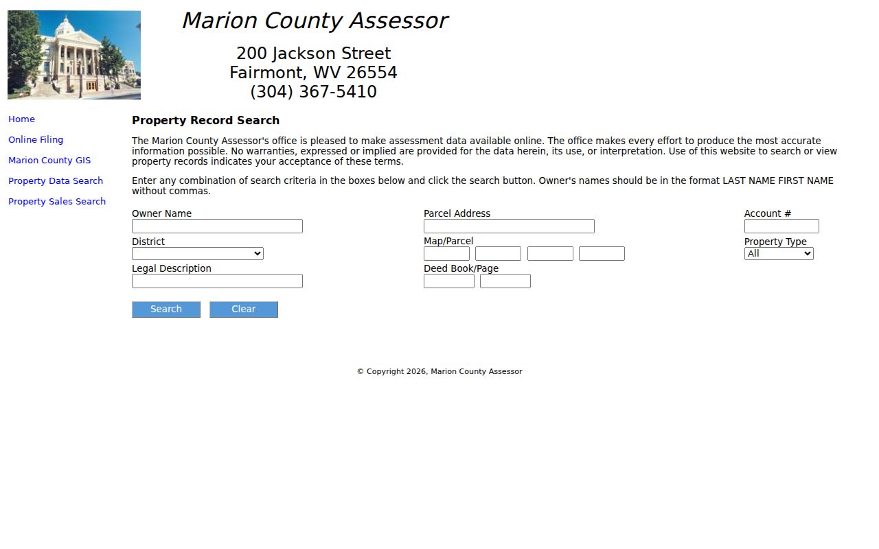
Its mix of address, parcel, legal-description, and deed fields makes it the main hinge between a street label and the county record chain.
Fairmont Street Directory Terms
County and map records use land terms that do not mean the same thing as a postal address. Defining them before copying a result prevents a common error: treating the owner, mailing address, and place being assessed as one household.
- Parcel
- A mapped unit of land used for assessment and record references. One postal address can involve more than one parcel.
- Situs address
- The physical location assigned to the property. It can differ from the owner's mailing address.
- Plat
- A recorded map showing lots, blocks, subdivisions, streets, or survey relationships.
- Criss-cross directory
- A directory arranged by street and house number, often used to identify an occupant recorded in a particular year.
Keep the parcel ID even when the goal is a simple Fairmont street directory lookup. Names and house numbers change. The land key and legal description are often the best bridge between the assessor, a plat, and the deed index.
Fairmont Records Listed by Address
No official current roster lists everyone along a Fairmont street. Instead, each custodian publishes or holds a record made for taxes, land transfers, elections, planning, or historical reference. The table separates what each address-keyed source can support and how to reach it.
| Address source | Custodian | Useful fields | Access route |
|---|---|---|---|
| Property roll | Marion County Assessor | Owner field, situs, district, map, parcel, legal description, deed reference | Free web form or assessor office |
| Parcel map | WV GIS and Fairmont Planning | Boundaries, map link, city limits, neighborhood and service layers | Free viewers |
| Recorded instruments | Marion County Clerk | Grantor, grantee, book/page, date, plat, lien or release | Land landing page, clerk counter, Archives |
| Registration record | WV Secretary of State and county clerk | Status, party, districts, polling place; approved lists add public address fields | Name-and-birth-date lookup or lawful list request |
| City filing | Fairmont departments and boards | Parcel, applicant, owner, agent, project, hearing or filing date | Agenda Center, forms, department request |
| Historical directory | WV Archives and local repositories | Year-specific occupant, address, work or household notation | Catalogue, library, archive, or available images |
Online access is only one channel. The assessor office is at 200 Jackson Street and lists 304-367-5410. The Secretary of State clerk directory lists the county clerk at 219 Adams Street and 304-367-5445, while the land page displays a different address and number. Call before a visit. Older deed books and indexes may require WV Archives or WVU reels.
Map Fairmont Streets to Parcels
The WV Assessment search adds Basic, Appraisal/Sales, Advanced, and Prior Ownership views. Results can show a root parcel ID, current owner field, property address, county, district, map, parcel, flood indicator, deeded acres, land-use and tax classes, and appraisal figures. A CSV Results link and Property Viewer route were present in the captured search.
The captured statewide assessment result is shown below from its official query page.
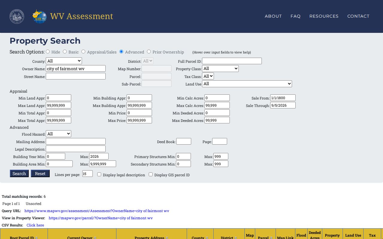
The result layout helps verify that the same street address is tied to the same county, district, map, and parcel before moving into land records.
For spatial context, the WV Statewide Parcel Viewer is map-oriented. Fairmont's ArcGIS item also describes city limits, public services, transportation, recreation, neighborhood boundaries, and nearby-city layers. Locate the street segment, select a parcel, then reconcile its ID in the assessor. Do not claim a buffer or export tool unless the live viewer confirms it.
Read Fairmont Street Layers
A street address has postal, legal, tax, election, and city-limit layers. They can disagree without any record being wrong. USPS formats delivery and assigns ZIP information. The assessor places land in a county district. GIS shows parcel and city boundaries. Election records use precinct and district lines. A deed may rely on a lot, block, subdivision, or metes-and-bounds description instead of the modern house number.
Fairmont's standard ZIP is 26554, while 26555 appears as a PO Box or mailing variant. Established postal data can associate Fairmont-area names such as Bellview, Jordan, Monongah, Pleasant Valley, and White Hall with 26554. Those associations do not decide whether land lies inside Fairmont. Use the USPS ZIP Lookup for the mailing line and city GIS for the municipal boundary.
Question: Does a Fairmont mailing address prove city residence? No. A postal city and ZIP describe delivery geography, while the city boundary, tax district, parcel, and precinct come from other official systems.
Fairmont Streets Changed With Growth
Historical street work needs old place names. Fairmont began with Boaz Fleming's 1787 settlement, was known as Middletown in the early nineteenth century, and incorporated as a borough in 1843. The 1899 charter brought Palatine and West Fairmont into the city, while Bellview incorporated in 1913. An old directory, deed, or newspaper may use one of those community labels instead of modern Fairmont.
The city's comprehensive plan also records an 1876 fire around Adams and Madison that destroyed a 300 block and was followed by a brick requirement. That event can explain a sharp building transition, but it is not evidence that county courthouse books were lost. Search an old address with the exact street spelling, the former community name, a plat description, and nearby corner references.
This story matters to a street directory because addresses are time-bound. A building can keep its site while the city label, lot configuration, or house number changes. Mark any suspected renumbering as unverified until a plat, directory sequence, city filing, or certified boundary record supports it.
Find Fairmont Street Filings
City records add events to the parcel trail. Fairmont's Agenda Center can be searched by a time period, custom dates, terms, and board category. Planning Commission, Board of Zoning Appeals, Historic Landmarks Commission, Building Commission, and City Council files may name a street, parcel, owner, applicant, agent, architect, or speaker.
Building and planning routes include building and zoning permits, subdivision review, parcel mergers, certificates of appropriateness, variances, conditional uses, site plans, and map amendments. The vacant-building registration form asks for a building address, map and parcel, condition, utilities, owner classification, and owner or local-agent contacts. These are filing roles. None automatically identifies a resident.
- Search the full street name and a shortened form.
- Repeat with the parcel number or legal subdivision term.
- Record the meeting or filing date and board category.
- Label each named person by the role stated in the record.
If attachments are missing online, contact the City Clerk, Planning, or Code/Building office through the city staff directory. A focused request for one parcel and date range works better than asking for all people connected to a street.
Link Fairmont Streets to Deeds
The Marion County land page lists deeds, deeds of trust, liens, releases, plats, assignments, agreements, affidavits, cemetery deeds, and trustee-sale records. Start with the assessor's deed book and page. Then read the recorded instrument for the grantor, grantee, dates, legal description, and parcel references. A deed supports an ownership or instrument trail; it does not list all occupants.
West Virginia law requires county indexes for grantors and grantees across several recorded writings. The county landing page did not expose its exact current search fields, image span, or copy price during research. If the online route stops short, ask the clerk for the index entry and image. For older work, WV Archives lists Marion deed books from 1842 through 1901 and a deed index from 1842 through 1968.
The two clerk sources disagree on contact details. The state directory lists Julie Kincaid at 219 Adams Street, PO Box 1267, Fairmont WV 26555, 304-367-5445. The land page displays 217 Adams Street and 304-367-4880. Verify which counter and number are current before traveling.
Check Older Fairmont Addresses
Selected Fairmont directory runs can place a household, business, or named adult at an address in one publication year. The WV State Archives lists volumes from 1901 through 2002 with many gaps. The collection is not an annual continuous run. For full holdings and how entries are read, use the Fairmont city directory resource.
The Marion County Public Library Genealogy Room at 321 Monroe Street combines directories with family histories, obituaries, maps, photographs, local publications, cemetery material, and vital or census leads. The Library of Congress Fairmont West Virginian run from 1904 through 1914 adds searchable OCR and page images. OCR helps find a street string, but names and numbers should be checked on the scan.
Compare one year at a time. A directory occupant, deed owner, tax addressee, and permit applicant are distinct roles. This is the central rule for using historical evidence in a Fairmont street directory without turning a dated clue into a present-day claim.
Limits of Fairmont Street Records
Public sources do not reveal every person at an address. The assessor generally names an owner-of-record, not all residents. The voter status lookup requires a known first name, last name, and birth date, and a result does not prove current occupancy. County voter lists have use limits and keep phone, email, Social Security, and driver or state-ID data private. City utility contacts are not a public household roll.
Protected or confidential addresses require special care. West Virginia's Address Confidentiality Program gives eligible survivors a substitute address for several agency uses. Never try to defeat that protection. When a lawful public record request is needed, direct a narrow request to the right custodian under the West Virginia Freedom of Information Act and expect exemptions to apply where required.
Lawful use. Use Fairmont address records for responsible property, family, civic, or historical research. Never use a street directory to stalk, harass, intimidate, or harm anyone.
State the result at the level the record supports: “owner named on the assessor card,” “party to a recorded deed,” “applicant in a planning file,” or “occupant listed in the 1947 directory.” That careful wording is more useful than an unsupported claim about who lives there now.